Showing posts with label summary. Show all posts

Wednesday, June 6, 2012

Meteorological Spring 2012 recap

The month of May finished warm and wet across much of the state, which was typical of spring.  Both Minneapolis and St. Cloud recorded the second wettest May on record with 9.34" and 8.76" of rainfall, respectively.  A large swath of Minnesota saw anywhere between two to four times normal precipitation for the month. 

mayppdev

During the month, as much as ten inches of rain fell just west and north of the Twin Cities, causing area rivers to rise rapidly to near or at flood stage.  The National Weather Service in Chanhassen recorded 11.23" of rainfall in May.  Over half the days in May brought measurable rainfall.

May2012precip

Soggy conditions persisted through the second half of the meteorological spring with central Minnesota receiving more than normal rainfall for the season to eliminate drought concerns by the end of May across the same areas.  The total precipitation in the Twin Cities from March to May this year was 13.78 inches, or 5.87 inches above normal.  Precipitation at MSP as of May 31, 2012 is 15.85 inches.

rainsurplus_spring12

springppdev_12

mn_dm_05292012

May was also known to be a mild month.  Nearly the entire state saw temperatures above the mean.  The Twin Cities was 4.6 degrees above normal, with St. Cloud also checking in above normal at 3.8 degrees.

maytempdev

May contributed to the warmest spring on record for locations in central and southern Minnesota including the Twin Cities, St. Cloud and Rochester.  The Twin Cities recorded a mean temperature of 54 degrees.  Duluth tied the warmest spring on record, and International Falls had the fourth warmest spring.  March 2012 was the main reason for the extremely warm spring, and nearly single-handedly carried the seasonal average to the number one warmest!

MSPspringtemphistory

It was quite the unusually spring with a little bit of everything, from droughts to floods, and an unprecedented mild March!  If spring was any indication, summer will be quite the three month ride.  Buckle up!

RS

Tuesday, January 10, 2012

December weather summary

December continued the ongoing trend of warmer than average temperatures, and lack of winter-like weather conditions. The average temperature in the Twin Cities during the month was 27.8 degrees – finishing 8.1 degrees above normal. According to the National Weather Service in Chanhassen, this was the 13th warmest December in Twin Cities modern history. High temperatures were well above normal during the second half of the month, and saw temperatures soar into the 50s the day after Christmas.  Many lakes are suffering from thin ice, prompting warnings from the Minnesota DNR.

KMSP201112plot-2

Dec2011TempsMSP

Looking at other locations around Minnesota, the St. Cloud temperature pattern was nearly identical to the Twin Cities and finished 9.3 degrees above average for the month at 25.2 degrees.

KSTC201112plot-2

STCDec2011Temps

The trend was much the same across the state with above average everywhere. A good portion of Minnesota was running anywhere from five to ten degrees above normal.

dec11tempdepart

Our mild temperatures brought a couple episodes of rain to the area in December.  Since the ground remained unfrozen, this moisture was able to seep into the moisture-derived soil.  0.99 inch of liquid precipitation fell officially at MSP airport, which was close to normal with a 0.17 inch deficit.  For the year, Minneapolis-St. Paul finished with 26.91 inches of precipitation, which was 3.7 inches below normal.

Dec2011precipMSP

KMSP2011plot

With the late month snowfall and rain across southeastern Minnesota, those areas ended up near normal for December in terms of precipitation.  A large portion of Minnesota saw 25 to 50 percent of normal December precipitation, which did not improve on the drought situation.

dec11precipdep

Stay tuned for more updates on January’s weather!

RS

Saturday, December 10, 2011

A look back at the December 10-12, 2010 snowstorm and blizzard

Between December 10th and 12th, 2010, a paralyzing snow fell over much of southern Minnesota.  By the conclusion of the event, it would have historic impacts - it was the largest snowfall in nearly 20 years for the Twin Cities since the Halloween Blizzard of 1991, the largest snowstorm to affect the Twin Cities in December, and the fifth largest snowfall from any one storm on record in the metro.  The Minnesota Climatology Working Group named it the third biggest weather event of 2010.  It also ranked third on my personal list of top weather events for the year.

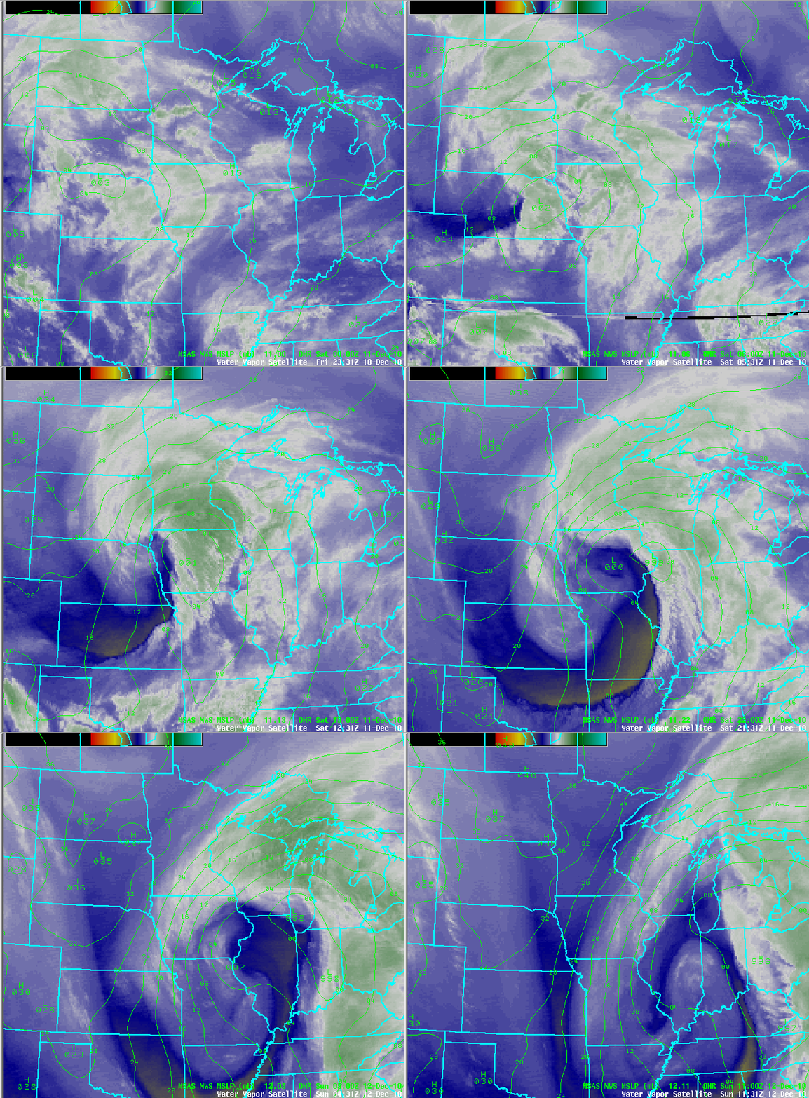
A very potent winter storm developed over South Dakota and Nebraska on Friday, December 10th.  It was an unusual storm in that it was a Pacific type storm system, which are not known to be high snowfall producers due to the limited amount of moisture available.  The moisture transport for this system was along an “atmospheric river”.  Here is an animated loop of the storm system as it moved across the Upper Midwest:
Dec112010_wv_small

Precipitation began as freezing rain, with sleet across far southern Minnesota on the evening of the 10th.  Eventually enough cold air wrapped into the system to cause all precipitation to change over to snow before midnight.  Snow continued into the day on Saturday, December 11th.  Radar loop of the precipitation as it moved through the area during the duration of the event:

Dec112010_radar

The storm system strengthened as it moved into Iowa through the 11th, and brought the highest snow accumulations during the morning and afternoon hours.  The deepened low pressure area created a tight pressure gradient in the atmosphere to generate strong winds and blizzard-like conditions across southern Minnesota, including the southern parts of the Twin Cities metro (Carver, Scott, and Dakota Counties).

Visibilities to one-quarter mile or less was reported at MSP airport during a seven hour span on December 11th. This resulted in the airport being shut down for four hours.  The poor visibilities were captured by a fixed camera I set up at my weather desk in Shakopee.

The storm system then moved east Saturday night, causing the snow to come to an end across southeast Minnesota by the morning of December 12th.  The weight of all the snow collapsed the roof of the Metrodome in Minneapolis during the early morning hours.

The highest concentration of snow occurred across east central and southeast Minnesota. A total of 17.1 inches of snow fell officially in the Twin Cities at Twin Cities International Airport during the 10th (0.8 inch) and 11th (16.3 inches).  Locally, I measured 21.5 inches of snow from the storm on the front sidewalk.  It was a challenging snow to measure with winds from 25 to 40 MPH causing snow drifts.  Here was the view from outside my front door just before 1 PM on the 11th:

029

Our neighbors on the east side of the St. Croix, Eau Claire, Wisconsin, picked up 22 inches of snow in one day, setting a new record. The largest Minnesota snow total was 23 inches recorded in the southeastern city of Winona.  Here are snowfall totals across the state from the National Weather Service in Chanhassen:

Here is a closer look at snow amounts in the Twin Cities, and reports from the seven-county area listed by inches, city, and county:

metrosnow

  • 21.0, OAKDALE, WASHINGTON
  • 20.0, MAPLEWOOD, RAMSEY
  • 18.0, (3 SSW) BURNSVILLE, DAKOTA
  • 18.0, (2 W) PRIOR LAKE, SCOTT
  • 17.5, (3 NW) MINNEAPOLIS, HENNEPIN
  • 17.4, LAKEVILLE, DAKOTA
  • 17.2, WOODBURY, WASHINGTON
  • 17.2, (1 W) CARVER, CARVER
  • 17.1, MINNEAPOLIS, HENNEPIN (MSP AIRPORT)
  • 16.5, SAVAGE, SCOTT
  • 16.3, HASTINGS, DAKOTA
  • 16.1, BLOOMINGTON, HENNEPIN
  • 15.5, CHANHASSEN, CARVER (NWS OFFICE)
  • 15.2, ST LOUIS PARK, HENNEPIN
  • 14.7, WACONIA, CARVER
  • 14.5, (3 SSW) WHITE BEAR LAKE, RAMSEY
  • 13.5, (1 ESE) CHASKA, CARVER
  • 13.0, STILLWATER, WASHINGTON
  • 11.5, ANDOVER, ANOKA
  • 10.8, CHAMPLIN, HENNEPIN

This was a memorable storm for several reasons.  It may also be considered this generation’s 1991 Halloween Blizzard for those who may not have been old enough to recall that event, or were not living in the area.

Additional information on this event:

RS