Showing posts with label severe thunderstorms. Show all posts

Thursday, August 16, 2012

Storm reports from Wednesday night

Thunderstorms developed across far western Minnesota during the late afternoon and pushed eastward.  As night came, the air began to stabilize a bit, and the storm complex started to lose signs of life.  During the initial hours, severe weather did occur and large hail fell.

MPX_DHR_1208160159_800x600_none__173_an

Here is a listing of hail reports meeting severe criteria received by the National Weather Service from Wednesday night.  Golf ball size hail occurred near Donnelly in Stevens County.  Half-dollar size hail was seen near the cities of Morris and Benson.

hailreports_081512

Another reason the storms fell apart as they approached the Twin Cities was that conditions were not favorable for severe thunderstorms.  The 7 pm observations from Chanhassen indicates the atmosphere was capped.  In addition, CAPE values (an indicator of instability) were low, indicating a minimal chance for severe thunderstorms.

mpxob_00z081612

This has been the story all year long. It seems as if one ingredient has always been missing for severe weather, leading to many busts.  It makes me almost believe that “It’s 2012, storms just don’t get real bad here”.

RS

Wednesday, August 15, 2012

A few severe thunderstorms with gusty winds possible today

After a long stretch of quiet weather throughout July and first half of August, the threat for severe thunderstorms returns to the area today as a strong cold front will be moving through Minnesota during the evening hours.

svrthreat_081512

Temperatures are expected to be near 90 degrees across southern Minnesota, with dew points approaching 60 degrees will create just enough instability for convective activity later on today.

eta24hr_sfc_temp_081512

eta24hr_sfc_dewp_081512

Damaging winds are the greatest threat from any of the thunderstorms today as storms are expected to be linear in nature along the cold front pushing eastward.  Winds will have the potential to reach 55 to 60 mph.

The Storm Prediction Center highlights this below:

THE GREATEST SEVERE POTENTIAL HOWEVER -- LIKELY IN THE FORM OF DAMAGING WINDS ASSOCIATED WITH A WELL-ORGANIZED LINE AND POSSIBLY SOME BOWING STRUCTURES -- IS EXPECTED ACROSS A PORTION OF THE ERN DAKOTAS BUT PARTICULARLY MN...FROM FROM MID AFTERNOON THROUGH EARLY EVENING. SOME THREAT MAY CONTINUE EWD INTO WRN PORTIONS OF THE UPPER GREAT LAKES REGION LATER IN THE EVENING...BUT DIURNAL COOLING/STABILIZATION SUGGEST LESSER POTENTIAL THAN EARLIER/FARTHER W.

windthreat_081512

Timing.  Storms are expected to develop during the early evening hours in western Minnesota from near Bemidji to Alexandria.  This is where the greatest concentration of energy for initiation will be located.

NAM_221_2012081506_F18_EHI_3000_M

The line should be into the Twin Cities around 9 to 10 pm, but intensity should diminish once the sun sets and we lose daytime heating, allowing attrition to come into play.  Storms this time of the year are very dependent on heating.  Here is one of the high-resolution models at 9 pm tonight (click the image to enlarge):

4kmWRF_081512_26

I believe the threat for damaging winds will be the greatest west of an International Falls, Grand Rapids, St. Cloud, and Worthington line.  The Twin Cities may see a few strong/severe storms storms depending on when the line begins to lose some of it’s punch.  It will be something to monitor later today.

RS

Friday, July 6, 2012

A few strong to severe thunderstorms mainly west and north of the Twin Cities today

A meandering frontal boundary across southern Minnesota will be the focus for thunderstorm activity on Friday.

94fwbgus_070612

Strong to severe thunderstorms will be possible across central into southwestern Minnesota near a low pressure center.  A capping inversion is forecasted to break by the afternoon to allow storms to develop.

RAP_255_2012070610_F15_EHI3_SURFACE

The high-resolution WRF model places heavy (severe?) thunderstorms across southwest Minnesota by 7 pm.  MSP is represented by the red dot.  Any thunderstorms that do develop across southern Minnesota will affect the Twin Cities after midnight, and will likely be a marginal severe weather threat.

4kmWRF_070612

Another one of the models paints the heaviest of the weather to the north, near the Lake Mille Lacs area.  So there is some disagreement within the models are where the storms will form today, therefore a broad area from east central into southwestern Minnesota will be highlighted for the threat of severe thunderstorms.

rad26_070612

The main threats from any severe thunderstorms will be large hail and damaging winds.  Another factor will the heavy rains.  Between now and 6 am Saturday, one to two inches of rain is possible across the Northland.  This is an area that does not need anymore rain.  Duluth is still drying out from flooding, and water levels on the lakes and rivers that run through Aitkin County are high.

fill_94qwbg_070612

There is still a bit of uncertainty with today’s severe weather setup, but it is always a good idea to have a means of receiving weather alerts ready to go.

RS

Monday, July 2, 2012

Hot, with severe thunderstorms possible over the Northland

A warm front, or is this instance, a “hot” front will move to the International border by this evening.  This front will be the focus for thunderstorms, some of which will be severe across the north.  To the south of the front, very warm air will dominate the state today.

94fwbgus_070212

The greatest area of concern for severe thunderstorms is north of a St. Cloud line, but the focus for storm development will be near the warm and cold front intersection.

NAM_221_2012070200_F21_EHI_3000_M

The Storm Prediction Center has indicated hail as the greatest threat today, with the purple area below as the area at risk.

hailthreat_070212

Unlike yesterday’s setup, a tornado threat does exist today as an area of low pressure moves into the northwest portion of the state.  Areas northwest from Bemidji may see an isolated risk of a tornado during the early stages of severe weather.

NAM_221_2012070200_F24_EHI_1000_M

The high-resolution WRF model at 7 pm below depicts a bow echo moving through the Northland tonight, with a secondary bowing mesoscale convective system forming near Fargo and moving southeastward.  The Fargo bow misses the Twin Cities to the north.

rflslp24_070212

Further south, it is just going to be hot.  Dew points in the 70s will keep temperatures from reaching 100, but highs around 95 degrees should be doable today in the Twin Cities.  The mid 90s will dominate most of southern Minnesota.

MNtemps_070212

A heat advisory is in effect for the southern half of Minnesota today until 10 pm as heat indices will top 100 by the afternoon.

heatadv_070212

Stay cool today!

RS

Monday, June 18, 2012

Active Sunday evening across Minnesota

A line of strong to severe thunderstorms moved through west central and east central areas of Minnesota Sunday night causing high winds, flooding, and numerous funnel cloud reports.  The line weakened as it approached the Twin Cities as drier, more stable worked into the system from convection earlier in the day.

MPX_N0R_1206180357_800x600_none__2595_an

Dew points were most impressive across northeastern South Dakota and far west central Minnesota at 7:30 pm Sunday.  Despite the models printing a large MCS (mesoscale convective system) coming into the Twin Cities by 10 pm or so, I knew it was going to lose a bit of punch, and questioned whether it would be severe by the time it arrived into MSP.  I think weather folks tend to get too excited about what the computers are telling them and assume the worst without looking at other information.  One can not forget the basics, such as surface observations.  Have to ask yourself, “Does this model solution make sense?”

MSLDPWinds_061712

Only one official tornado report was received Sunday east of Wheaton, Minnesota.  There were many reports of funnel clouds and thunderstorm wind damage across west central Minnesota.  The highest wind gust observed was 77 mph in the town of Cosmos at 9:56 pm.

stormreports_061712

The National Weather Service offices were busy issuing warnings all night.  Tornado warnings clipped the far west metro, and severe thunderstorm warnings extended all the way to the St. Croix River.  The Twin Cities saw heavy rains, two to three inches, on already saturated ground, triggering flash flood warnings.

nwswarn_061712

It was definitely a busy night, and we could see more storms on Tuesday.  Look for additional updates as they are warranted!

RS

Monday, June 11, 2012

Did the Sunday storms produce a tornado?

As expected, a line of strong to severe thunderstorms rolled across Minnesota Sunday night ahead of a cold front.

MPX_N0R_1206110200_800x600_none__173_an

Widespread damaging wind reports were received throughout the state, and at one time, 18,000 Xcel Energy customers were without power in the Twin Cities.  Some of the more interesting storm reports received that involved structural damage are below.  The majority of the wind reports involved tree damage.

svrstormreports_061012

Things really become interesting after 8 pm when a tornado warning was issued at 8:18 pm on a cell heading into southwestern Scott County.

* AT 814 PM CDT...RADAR INDICATED A STORM CAPABLE OF PRODUCING A TORNADO. THE MOST DANGEROUS PART OF THE STORM WAS 6 MILES SOUTHWEST OF BELLE PLAINE...OR ABOUT 4 MILES EAST OF HENDERSON...AND MOVING NORTHEAST AT 50 MPH.

torwarn061012

Strong rotation was detected on radar as the cell travelled between Belle Plaine and Jordan.  Damage in the Belle Plaine area included, “Roof blown off house, shed down, and a 48 foot grain bin blown into a field.”

belleplainerotation

Was this a tornado?  Based on what I have seen on radar, there is pretty good evidence that it was.  However, the National Weather Service in Chanhassen will conduct a formal damage survey to determine if the damage was caused by straight-line winds or a tornado.  If it is indeed ruled a tornado, this would be the first tornado to impact Scott County in almost two years.  The last tornado in the county occurred on June 26, 2010 near Elko New Market.  Damage was reported to trees and a silo in that storm.

scottco2010tor

RS

Sunday, May 27, 2012

Timing of the severe weather threat

A lifting warm front and an advancing cold front will set the stage today for severe thunderstorms as temperatures reach the 90s across the southern two-thirds of Minnesota and tropical dew points near 70.

analysis_05272012

Large hail and damaging winds will be the greatest threats from any storm.  The tornado risk is low due to unidirectional wind from the surface to upper-levels of the atmosphere.

Significant hail threat today:

hailoutlook_052712

Wind threat:

windoutlook_052712

The hot temperatures along with the moisture in the area will be create a strongly unstable environment by the evening hours after peak daytime heating.  CAPE values near 3,000 J/kg and a lifted index around –10 will provide more than enough “juice” and lift to produce isolated to widely scattered severe thunderstorms during the latter part of the day.

CAPE:

RAP_255_2012052711_F09_CAPE_SURFACE

Lifted Index:

RAP_255_2012052711_F09_LFTX_500_1000_MB

As far as timing of the storms today, the forecast models seems to be all over the place, but I am favoring the thunderstorm activity to move through the Twin Cities late tonight into the early overnight hours.  Right now it appears storms will fire after 6 p.m. across western Minnesota, then slowly progress eastward towards the Twin Cities after nightfall.  The Twin Cities will be impacted sometime between 11 p.m. and 1 a.m.

today_1h_f23_052712

1ref_t2sfc_f13_052712

rad22_052712

Euro_052712_06z

Stay safe today if you have any outdoor plans, especially late in the day, then keep it tuned to Stormchaserschwartz.com and StormChaser Schwartz social media outlets for additional information today!

RS

Thursday, April 12, 2012

Severe potential this weekend

A potentially explosive severe weather situation is setting up over the Central Plains this weekend as a low pressure area, with associated warm front and dry line, set up east of the Rockies on Saturday.

sfcmap_04152012_00z

A moist, unstable air mass is forecasted behind the warm front and out ahead of the dry line.

Strong south winds at the surface turning more westerly with height will help create enough shear in the atmosphere for rotating supercells.  These supercells will be capable of producing tornadoes, perhaps large and destructive ones.  In addition, large hail and damaging winds can be expected.

Winds at 850 millibars (~5,000 feet):

NAM_221_2012041300_F42_WSPD_850_MB

Winds at 500 millibars (~18,000 feet):

NAM_221_2012041300_F42_WSPD_500_MB

The area where I see the greatest threat for severe thunderstorms, including tornadoes, is over eastern Nebraska and western Iowa.  If I wasn’t going to a Twins game Saturday at Target Field, I would consider the Sioux City, Iowa area as an initial chase target.

NAM_221_2012041218_F48_EHI_3000_M

As for Minnesota, it will all depend on where the warm front lines up.  If the models move it further north over the next day, then the chance for severe thunderstorms increases in the area.  Right now, the bulk of the heaviest weather should stay south of the Interstate 90 corridor.  Any strong storms that develop north of the warm front in an elevated environment will be capable of hail and gusty winds.

RS

Tuesday, March 20, 2012

First bout of severe weather to end Winter

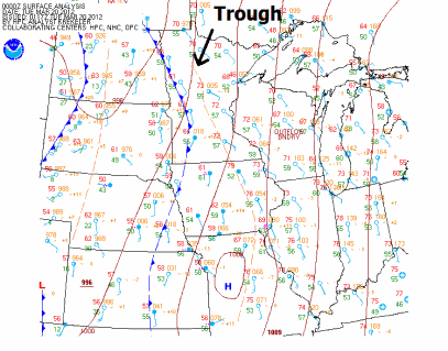
Our final day of astronomical winter ended with a round of strong to severe thunderstorms across southern Minnesota.  These storms developed along a trough of low pressure in a slightly unstable environment with temperatures in the mid to upper 70s, and dew points near 60 degrees.  Here is the surface map from 7 PM Monday.
namncsfcwbg

Going into the day, clouds and limited instability appeared to hamper any widespread severe weather outbreak across much of the state.  Satellite imagery from 11:45 AM Monday.

sat1645z_03192012

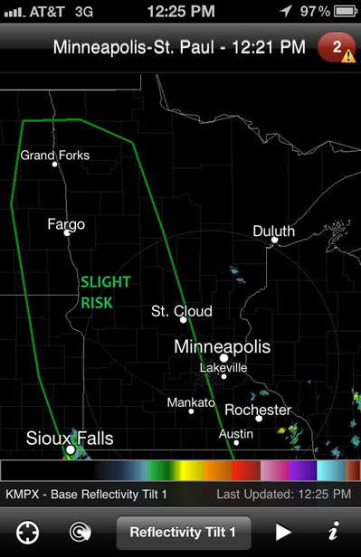
By the noon hour, the Storm Prediction Center determined that enough instability was in place for isolated severe storms ahead of an advancing cold front along the Minnesota/Dakotas border to include western Minnesota in a slight risk for severe thunderstorms.

...MO/IA NWD TO THE ERN DAKOTAS/WRN MN THROUGH TONIGHT... BOUNDARY LAYER DEWPOINTS IN THE MID-UPPER 50S BENEATH STEEP MIDLEVEL LAPSE RATES WILL SUPPORT A CORRIDOR OF WEAK-MODERATE INSTABILITY IN ADVANCE OF THE COMPOSITE OUTFLOW BOUNDARY IN MO/IA...AND THE SURFACE FRONT ACROSS THE ERN DAKOTAS. SOMEWHAT UNIDIRECTIONAL PROFILES WILL SUPPORT A RISK FOR ISOLATED DAMAGING WINDS/HAIL WITH A BROKEN BAND OF STORMS ALONG/AHEAD OF THE FRONT THIS AFTERNOON/EVENING ACROSS THE ERN DAKOTAS/WRN MN. STORM COVERAGE IS MORE CERTAIN FARTHER S INTO MO/IA WHERE CONVECTION IS EXPECTED TO INTENSIFY THIS AFTERNOON ALONG THE COMPOSITE OUTFLOW BOUNDARY NOW MOVING INTO WRN MO/IA. SOMEWHAT STRONGER LOW-LEVEL SHEAR /COMPARED TO FARTHER N/ WILL PROMOTE A RISK FOR EMBEDDED ROTATING STORMS IN A PREDOMINATELY LINEAR CONVECTIVE MODE...WITH AN ATTENDANT RISK FOR DAMAGING WINDS/ISOLATED TORNADOES.
383561_370890092932987_194214277267237_1284205_1833109873_n

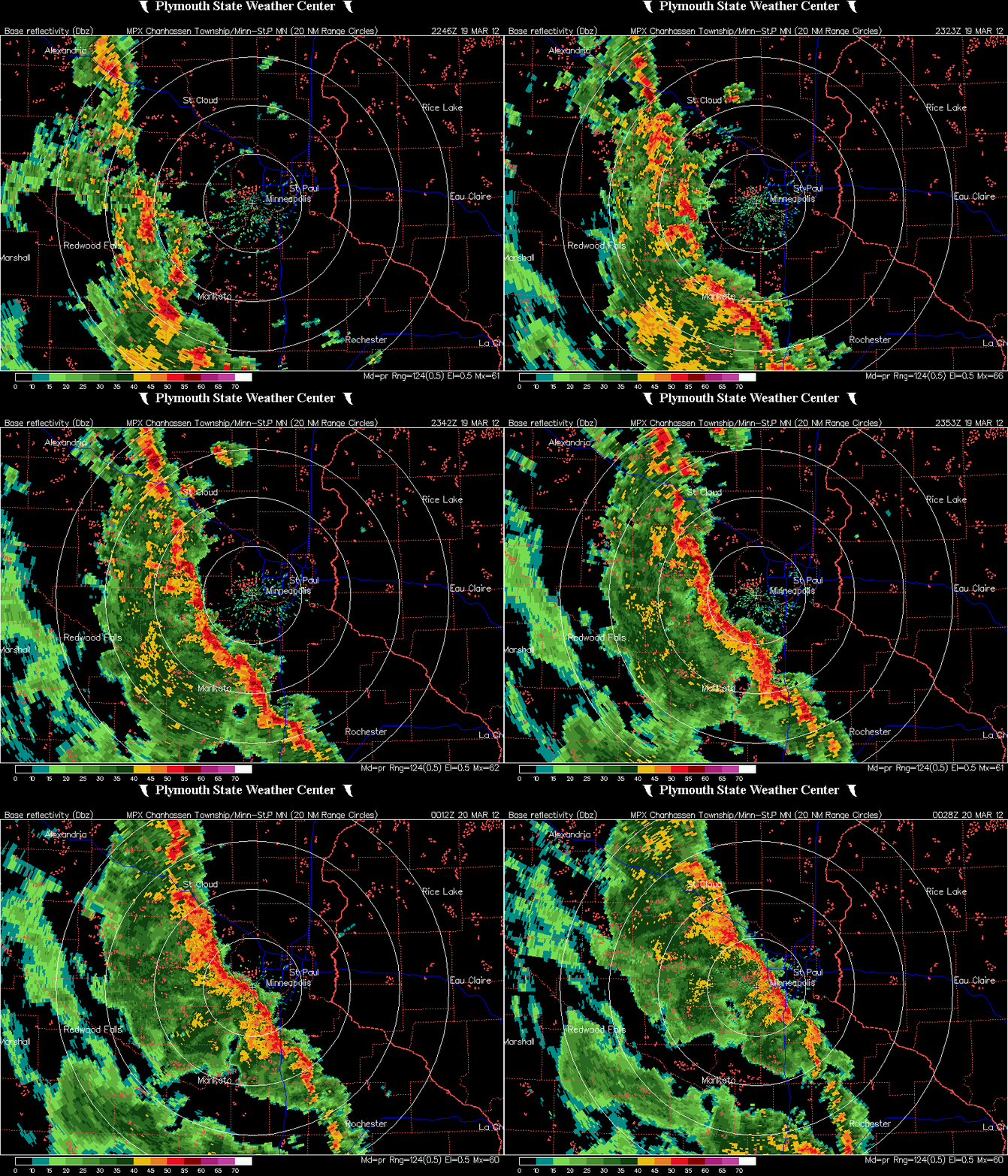
During the early evening hours, a line of storms developed and moved northward out of Iowa towards the Twin Cities.  On radar, the line showed signs of bowing out in Freeborn and Le Sueur Counties, indicating strong winds.  Radar loop of the storm approaching the Twin Cities is below.
MPX_N0R_1203200028_800x600_none__173_an

All I saw while rushing out the door to catch this storm in Shakopee was winds to 35 miles per hour, and torrential rainfall that brought traffic to a crawl as drains tried to keep up with all the water.  Cloud to ground lightning was also evident as the leading edge approached.  The heaviest damage based on storm reports came from the town of Elysian in Le Sueur County.  There was an unconfirmed report of a tornado by the public as numerous roofs were ripped off between Lake Elysian and Lake Francis.  The National Weather Service in the Twin Cities may be doing a survey as early as Tuesday to determine whether the damage occurred from straight-line winds or a tornado.  The earliest verified tornado in Minnesota occurred on March 18, 1968, north of Truman, MN (Martin County).

Additional damage happened further south.  Here is storm damage to a grain silo from the Albert Lea area shared by Rusty Dawkins, Chief Meteorologist for KAAL-TV in Austin, MN, on Twitter:

Here are storm report highlights of wind damage and thunderstorm warnings issued during the duration of the storm:

stormwarndamage

Many locations across the state saw upwards to an inch of rain, with a few isolated places seeing close to two inches.  Here is a radar estimate of total rainfall from Monday:

rain03192012

Overall, it was a pretty mild-mannered thunderstorm event with isolated severe storm damage across the south central part of Minnesota.  The Storm Prediction Center had some difficulty figuring out this storm system with uncertainty in variables, but in the end I feel they made the right call by not issuing any severe thunderstorm watches as the storms posed a marginal severe threat for much of the evening.  A watch in under these conditions would have created a lot of public hysteria for so early in the year.  This event definitely had more bark than bite.

RS