Sunday, July 10, 2011

Dry Sunday with heavy rains possible overnight

Another warm and sticky day is on tap for Sunday as temperatures will soar into the 90s with dew points in the low 70s. A cold front will move in from the Dakotas and stall over the central part of Minnesota during the overnight hours into Monday.

94fwbgus

The stalled front will lead to rainfall amounts around one inch with some isolated higher amounts northwest of the Twin Cities metro.

wrfGL_0_prec_30

The severe weather set up appears to be better defined going into Sunday, but I’m expecting the severe weather to stay well to the west and south of Minnesota.  Highlighted below is the area where I believe the greatest concentration of severe weather will occur.  High winds and large hail will be possible across the entire area of severe risk.  A tornado threat will exist across northeast South Dakota, around the Aberdeen area, due to higher wind shear values forecasted into Sunday night.

NAM_221_2011071000_F24_EHI_3000_M

As the storm activity crosses the border into Minnesota from South Dakota, the storm will evolve into a complex or line, referred to as a mesoscale convective system (MCS).  This will trigger the heavy rains that the forecast models are indicating around the midnight hour across the central portion of Minnesota.  We may be dealing with additional flash flood warnings.  Stay tuned!

RS

Friday, July 8, 2011

Shelf cloud vs. Wall cloud: Part Deux

Due to an overwhelming response to the Weather 101: Shelf cloud vs. Wall cloud post, I’ve decided to post some additional shelf cloud and wall cloud examples that were supplied to me with permission by fellow weather enthusiasts to illustrate proper cloud identification.

Each cloud type has different characteristics to provide clues as to what kind of weather can be expected in the short-term, so accuracy is important.  As discussed in the original post, an approaching shelf cloud is a strong indication of very gusty straight-line winds that can pose a safety hazard.  Straight-line winds have been known to reach or exceed 100 MPH, which is equivalent to an EF-1 tornado!  A nearby wall cloud means residents should be prepared to take cover.  Wall clouds are typically rotating, and are sometimes a pre-cursor to funnel clouds, which may eventually produce a tornado if the funnel extends all the way to the ground.

Wall cloud examples:

 Michael Thompson took this photo of a wall cloud near Crookston, MN on July 4, 2011.  Notice the distinct lowering of the cloud base.  (For great storm photos, I recommend following Michael’s blog.  His photos are professional, high quality.)


Wall cloud approaching downtown St. Paul, Minnesota from June 21, 2011. Video by David Blume, KD0IRF.

Shelf cloud examples:

 Michael Thompson took this photo of a shelf cloud rolling in near MSP airport on July 1, 2011.

Video shot by Michael Thompson of a shelf cloud approaching MSP airport on July 1, 2011.

As I was discussing this matter with Michael, he pointed out that a shelf cloud looks like a huge wall coming at you.  This is very true, and a big reason why the mistake in identity happens.  Hopefully, this additional media makes it easier to understand the differences between a shelf and wall cloud, so when severe weather occurs close to your neighborhood, you will know what kind of weather to expect!  I would like to personally thank Michael and David Blume for their outstanding contributions on this topic.  It’s amazing what a little collaboration and help among weather enthusiasts can do.  We all learn from each other, and in turn, it becomes a tighter knit group.  I cherish what I have learned from weather spotters, chasers, and enthusiasts that I have encountered over the last few years.  It’s truly amazing.

RS

Thursday, July 7, 2011

July outlook and a look back at June

(Between the 4th of July holiday weekend and going out on two storm chases already this month, I never got around to putting together a June summary and July outlook until now.)

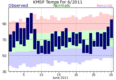
The month of June saw a hot start as temperatures soared well above average during the first eight days of the month, including the 103-degree reading in Minneapolis on June 7, before settling into a normal pattern for the remaining majority of June.  As far as temperatures, June turned out to be pretty typical even though we did not see many 80+-degree readings over the course of the 30 days.
KMSP201106plot-2

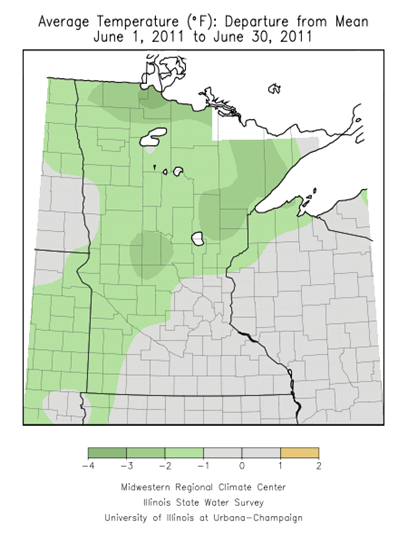
In Minneapolis, the average temperature for June was 69.5°F, which was 1.1°F above normal.  Areas north and west of the Twin Cities metro finished the month with cooler than normal temperatures, which is right in line with the Climate Prediction Center (CPC) forecast for June.  St. Cloud finished slightly above normal with temperatures 0.2°F above the average of 65.3°F.
Jun2011tempdev

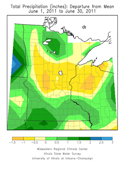
While we began the spring with a lot of rain, June was a dryer month for much of central Minnesota.  Rainfall was more than a half-inch deficit from normal in many spots.  This was actually welcome relief for farmers to help with saturated fields that led to slower crop growth.  Minneapolis finished with 5.28 inches of rain, which was 0.94 inches above normal.  St. Cloud saw a little more than half of that, coming in with 2.87 inches, which was 1.64 inches of rain below normal.  This contradicts the CPC precipitation forecast for June of above average rainfall for the state.
Jun2011precipdev

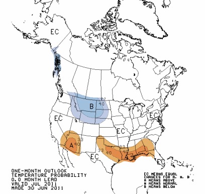
What does July have in store?  Looking at the CPC forecast, it appears we will see more seasonal summer weather with temperatures closer to July normals.  The effects of La Nina have since been long gone, and that should help temperatures begin to trend upwards.
off15_temp

According to the CPC, we should also see quite a bit of precipitation.  A good chunk of the state is expected to see well above normal rainfall.   This agrees with some of the model data I’ve been looking at through the middle of July.  It appears the weather pattern will be more unsettled and the state will see storm system after storm system work their way across the state.

off15_prcp

Between now and the 15th of the month, it is possible that parts of the state could see at least one or two episodes of severe weather. For a relatively quiet severe weather season in terms of the number of outbreaks we had, we may make up for it this month with the summer-like temperatures expected. The cooler temperatures so far this year has prevented widespread severe weather events from occurring.  It will be something to keep and eye on.

This is also a good opportunity to stress the importance of having NOAA Weather Radio as an alert device in your home to keep you safe from natural disasters.  RadioShack has many models available, from desktops to outdoor handhelds, are usually in-stock.  Midland Radio and Reecom are two other manufacturers I recommend.  A feature I highly recommend when looking for a weather radio is one with S.A.M.E. technology.  This will allow to select which county or counties you would like to be alerted, so the tone alarm isn’t sounding for every single alert in the weather radio transmitter signal range.  This is beneficial for the overnight hours when most people are asleep, and don’t want to be awaken to alerts for weather that will have no impact on their location.

Around the Twin Cities, NOAA Weather Radio is broadcast 24/7 on a frequency of 162.55 MHz, and will transmit weather information and emergency alerts for the 7-county metro area and other counties highlighted within the yellow outline below.

msp

Codes for programming your weather radio for specific counties are illustrated below.  In Minnesota, the S.A.M.E. code will be 027XXX, where XXX is the county you designate.  For example, for selecting Hennepin County alerts, the code is 027053.  Many weather radios will allow you to program a handful of counties, if you choose.  Some of newer weather radios have the county codes already built-in, so all you have to do is select the name of the county from the radio’s LCD display to make it easy and hassle-free.

SAMEmap

Enjoy the remainder of the week! I will be monitoring the potential for severe weather during the upcoming weekend, so be sure to check back for updates as we get closer to the end of the week.

RS

Wednesday, July 6, 2011

07.05.11 Norwood-Young America, MN

Thunderstorms developed along a stationary front draped nearly over the Twin Cities metro area during the late afternoon into the evening hours.

usfntsfc2011070600

Radar showing the thunderstorms over the metro.  Loop is between 6 and 7:30 PM. Click to enlarge.

MPX_N0R_1107060028_912x684_none__0865_an

As I left work for the day around 5:30 PM, I checked RadarScope on my phone and saw storms popping right overhead.  Walking out the door, rain was falling, and I noticed the billowing cumulonimbus clouds off in the distance towards the north from Wayzata.  The storms over Anoka County produced a waterspout over Coon Lake at approximately 5:45 PM.  Temperatures managed into get into the upper 80s despite the persistent cloud cover most of the day, so that provided the battle zone for the cool and warm air mass clash.  Heading home, I decided to head out on an impromptu storm chase, and picked up on the storm cell going through Carver County since it would be a shorter drive.  After stopping in Shakopee to pick up some dinner at Culver’s, I headed out on US-212 towards Norwood-Young America.  Once I arrived in town around 7 PM, I took Carver County Highway 33 south of town where I caught up with the storm.  It produced this rain shaft that was being reflected by the sun from behind.  Even spotted a rainbow right next to it as I got a little bit closer.  I’m glad no one reported this as a tornado, because it wasn’t rotating at all.

097

098

Another view of the rainbow with the rain behind it:

099

The storm didn’t seem to strengthen during the duration of the chase up to this point, and it was only producing heavy rains and some gusty winds in the core of the storm.  With that in mind, I decided to call it a day, and headed towards Minnesota Highway 25, where I met up with US-169 in Belle Plaine.  In Belle Plaine, I took the north US-169 exit towards home.  Heading into Shakopee, I was welcomed back with a nice looking cumulonimbus cloud off to the east from US-169:

103

102

It was a fun, little unexpected chase.  I love smaller storms such as this, because it’s easier to get better aquatinted with the road system in areas that I normally don't drive through since my mind is not distracted with extra tasks (observing wind readings, making sure video is working, playing around with the radio, submitting reports, etc.) during a severe weather situation.  Who needs an atlas when you have all the local back roads stored in the head?!

Total Reports: 0 (no severe weather witnessed)

RS

Monday, July 4, 2011

4th of July forecast

It will be a pleasant, storm-free day across much of Minnesota for America’s birthday with highs close to 90.  The high temperature for MSP will be around 88-degrees with a dew point peaking at a sticky 67-degrees, creating a heat index of 91-degrees.

Mother Nature will provide her own fireworks for the northwestern part of Minnesota, where the focus will be for thunderstorms, some of which may be severe.  The dynamics for severe thunderstorms are a bit marginal today, but I still expect a few isolated storms to become severe before the midnight hour around the Wadena and Alexandria areas.  Something to keep an eye on for folks going out tonight to watch fireworks.  Maybe a few rumbles of thunder are possible west of the Twin Cities metro, but I’m not expecting any severe.

today_1h_f26

Happy 4th of July!

052

RS

Sunday, July 3, 2011

Weather 101: Shelf cloud vs. Wall cloud

With the Friday night storms that moved through the Twin Cities area, there were many calls from the public into “The Good Neighbor” and folks on Twitter reported seeing a wall cloud close to their location. Was it actually a wall cloud? No. What these people were actually seeing was a shelf cloud with the line of storms. A couple friends pointed out to me when I arrived home from following the storms that even television media outlets were not immune from making this error while posting images.

I felt compelled to write this post to help educate what is being seen in the sky to avoid confusion in the future. At the end of the day, does all of this make a huge difference? No, but I think accuracy counts, and it makes it easier to listen to reports on the radio when they are 95% correct rather than 95% wrong. What I’m not going to do is “call out”, because quite frankly, a lot of people out there simply don’t know the difference, and it would be arrogant of me to do so otherwise. One of my goals as being a storm spotter is connecting with the public and educating people that see my work through my blog or social media websites, so they have a better understanding and appreciation for weather. I try to present weather as a fun, interesting, and informative topic. It can actually be pretty cool!

So without further ado, here is the difference between the two cloud formations:

shelf_over_mpx_JohnWetterShelf cloud at the National Weather Service in Chanhassen

The shelf cloud is horizontally elongated, and it’s something you typically see with a line of storms rather than an individual supercell thunderstorm. Winds are blowing away from a shelf cloud – known as the outflow. The National Weather Service defines it as, “A shelf cloud is a low, horizontal wedge-shaped cloud, associated with a thunderstorm gust front (or occasionally with a cold front, even in the absence of thunderstorms). A rising cloud motion often can be seen in the leading part of the shelf cloud, while the underside often appears turbulent, boiling, and wind-torn.”

wallcloudWall cloud image from the National Weather Service

Whereas the shelf cloud has more of a horizontal feature to it, a wall cloud on the other hand is a vertical lowering of the cloud base. These are what you see with rotating supercell thunderstorms, and are often a pre-cursor to funnel clouds and tornadoes if the conditions are just right. Winds are blowing towards a wall cloud – known as the inflow. The National Weather Service defines it as, “A wall cloud is a cloud formation associated with thunderstorms. It is a definite lowering of the cloud base typically beneath the rain-free portion of a cumulonimbus cloud, and indicates the area of primary and strongest updraft which condenses into cloud at altitudes lower than that of the ambient cloud base. Sometimes, the wall cloud will often be seen to be rotating. A rotating wall cloud is the area of the thunderstorm which is most likely to produce tornadoes, and the vast majority of intense tornadoes.”

Hope you found this to be informative for when you see weather roll in next time, you will know exactly what you are looking at!

RS

Saturday, July 2, 2011

07.01.11 Twin Cities MN

As I discussed in the morning, a cold front moving through the area was the focus for thunderstorm development, some of which produced damaging winds and large hail.  Here is the position of the cold front at 7 PM:

surfacemap

The hot air mass combined with the high dew points, created a very unstable atmosphere over the east half of the state.  The National Weather Service in Chanhassen put together this animated display of convective available potential energy (CAPE) values in 6 hour increments.  This was more than enough “juice” to keep storms going once they developed.

By mid-afternoon, severe storms were forming just north of Sioux Falls, SD, and quickly became severe. Sioux Falls radar from 3 PM:

FSDstorm

This storm cluster would be the first “wave” to hit the Twin Cities metro as it traveled eastward throughout the evening.  It produced very strong winds across the north metro, causing tree damage and knocking out power to residents. Click the image to enlarge.

1stwave

After I got home from work, I decided to chase some new storms forming along the south side of the first line of storms around the Shakopee and Eden Prairie areas to see if these might go severe.  These storms pretty much fizzled out as they moved through.  My attention then turned to a stronger line of storms moving towards the Twin Cities from the southwest. Click the image to enlarge.

2ndwave

It appeared that this second line of storms was trying to “bow” out, which is a sign of winds associated with the convection are in excess of 60 MPH and can do some damage!  These storms are also dangerous to chase because these types of storms bring heavy, wind-blown rain, which makes it very difficult to drive in.  It’s not a situation an ordinary person wants to be caught in.  I would take chasing supercells any day of the week.

After chasing the first line of storms, I headed south on US-169 towards Jordan to catch up with the second line.  Here are some highlights of an approaching shelf cloud, which is on the leading edge of very gusty winds.  I was also hearing reports on the radio by the public of this being called a wall cloud.  That is incorrect.  It’s important to know the difference between a shelf and wall cloud.  A shelf cloud has more of a horizontal feature to it and you’ll often see this with a line of storms featured on radar, as was the case on this day. A wall cloud is more of a vertical, lowering cloud, which are associated usually with supercells.

IMG_0557

Shelf cloud in the background behind the tree and Ford sign.  Picture taken near US-169 and Minnesota Highway 282.

001

Underside of the shelf cloud from near the Minnesota River crossing in Jordan.

IMG_0559

Another look underneath the shelf cloud traveling south on Scott County Highway 9 in Jordan.

Video highlight of the storm in Jordan:

I followed this line from Jordan north on US-169 through Shakopee and Bloomington, and then east along Interstate 494 into the southeast metro near West St. Paul before calling it a day since there wasn’t much happening with this line other than some non-severe winds and heavy rain on the roadways.

gpsplot

The highlight of this chase may have been of this photo I took of the sun trying to peak behind the clouds near sunset.  This was taken from the empty parking lot of the now shutdown Canterbury Park in Shakopee:

002

Here is graphic of the storm reports received by the National Weather Service.  The most concentrated damage appears to be west and north of the Twin Cities metro.  The second line of storms weakened as it moved into the heart of the metro, limited the damage. Click the image to enlarge.

lsr_07012011

Total Reports: 0 (no severe weather witnessed)

RS